Saturday, December 31, 2016

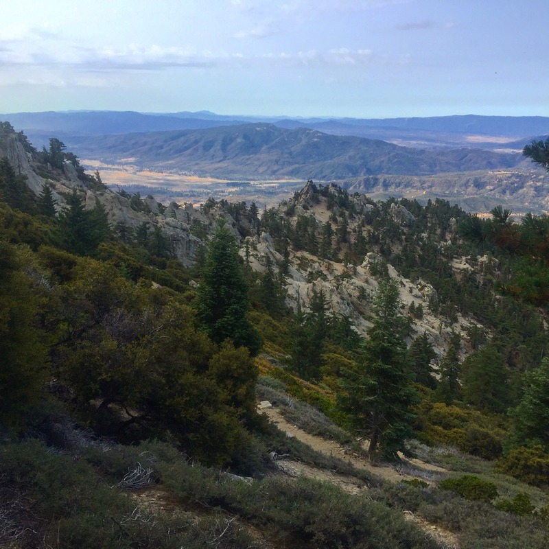
Hike #54 Monument Peak

52 Hike Challenge 2016 Adventure Series

5.25 miles | +1000'


"Rising up like a 6,000′ tall frozen wave threatening to crash over Anza-Borrego Desert State Park, the Laguna Escarpment features some of the most spectacular views anywhere in Southern California. The Pacific Crest Trail runs along the edge of this escarpment while offering access for numerous side trails to some of the 6,000′ peaks dotting the highest part of the crest. Monument Peak is the most accessible and prominent of these peaks, and from its summit, one can see clear to Arizona, provided that the weather conditions are optimal." -Scott Turner

Hike #53 Pyles Peak via Big Rock Park

52 Hike Challenge 2016 Adventure Series

9.5 miles | +2000'


Hiked the third highest summit in Mission Trails Regional Park with my sister. Now we just have two more, Kwaay Paay Peak and South Fortuna Mountain, then she'll have completed the Mission Trails Five Peak Challenge.

Hike #52 San Jacinto Peak

52 Hike Challenge 2016 Adventure Series

20 miles | +4500'


My first time up San Jacinto and my 52nd hike of 2016! Last year I completed a total of 55 hikes, so it looks like I'm well ahead of myself this year. Getting outside, away from the business of my daily life has allowed me to connect with myself and nature in a way that brings about peace, a sense of accomplishment, and well-being. John Muir knew what he was talking about when he said, “In every walk with nature, one receives far more than he seeks.”


This was by far my most difficult day hike. From Humber Park in Idyllwild, up Devils Slide Trail to Saddle Junction, left on the PCT to Wellman Divide and up San Jacinto Peak. Then down to Little Round Valley along Deer Springs Trail to Strawberry Junction, left on the PCT to pick it up where I left off and back down Devils Slide. Next time I'm taking the short route!

Hike #51 Coast Walk Trail

52 Hike Challenge 2016 Adventure Series

1 mile | +100'


Summer days and early evenings are perfectly suited for what could be the finest short walk along San Diego County's 60-mile-long Pacific Ocean coastline. Many but not all San Diegans and tourists are familiar with the unpaved Coast Walk pathway overlooking La Jolla Bay, atop the cliffs honeycombed with the La Jolla caves.

A cliff-hugging pathway threads between palatial houses and the unfenced brink of the cliffs. A footbridge and steps span a ravine that plunges some 100 vertical feet to the blue-green waters of the bay. On late summer evenings, during rare blooms of "red tide," the undulating water below pulses with bioluminescence -- a factlet you may want to remember for future reference. Beyond the ravine, a spur path and steps on the left go up to the intersection of Prospect Place and Park Row, another possible starting point. Keep straight. Right below you, unseen from this vantage, are the several La Jolla caves, some of which are exposed during low tide, and others that are never exposed to dry land at all.

Presently you will arrive at a grove of graceful Torrey pines on Goldfish Point. Although these trees grow naturally just up the coast at Torrey Pines State Reserve, they were planted here. The path ends just beyond this pine grove, next to the Cave Store, where you may -- if interested and for a fee -- descend some claustrophobic stairs going down a tunnel and into the dank, westernmost cave of the La Jolla cave series.


You've come the equivalent of a mere three city blocks, so feel free to continue walking on the paved sidewalk past La Jolla Cove, around the periphery of Scripps Park, and as far south along the La Jolla coastline as you wish.

Hike #50 North Fortuna Mountain

52 Hike Challenge 2016 Adventure Series

6.75 miles | +1030'


North Fortuna Mountain, at 1291 feet, is the third-tallest mountain in Mission Trails Regional Park after Cowles Mountain and Pyles Peak but the most challenging to climb because of the steep ascent and descent. It was certainly the most difficult hike my sister has ever attempted. I've been slowly helping her complete the Mission Trails 5 Peak Challenge. Two down, three to go.


North Fortuna is part of a long-arced mountain with two peaks that was once called on century-old maps Long Mountain. North Fortuna is separated from South Fortuna by a 910-foot saddle. This area has a long military history beginning in 1917 when Fortuna was used as an artillery target for training during WWI by the U.S. Army based at Camp Kearny, a few miles to the west. The area was reactivated in 1934 by the U.S. Marines, becoming part of Camp Elliott; ten years later, it was transferred to the U.S. Navy. Fortuna was used for tank, artillery, and infantry training for both WWII and the Korean War. After a cleanup for live ordnance, the land was transferred to the City of San Diego in the 1960s. By the late 1970s, a master plan was created for Mission Trails Regional Park. On rare occasions, live ordnance may surface after heavy rainfall and should be reported and never handled.

Hike #49 Mount Woodson

52 Hike Challenge 2016 Adventure Series

5 miles | +1200'


Of the four loosely defined geographic regions in San Diego County, the region between I-15 and the Peninsular Ranges probably gets the highest visitation and use. This is due to its accessibility to the heavily populated coast in addition to a wealth of different hiking opportunities. Many of the county’s iconic hikes, such as Iron Mountain, Mission Hills, Daley Ranch, El Cajon/El Capitan, and, of course, Mt. Woodson, are found here. On any given weekend, these locations are crawling with hikers, but perhaps none quite as much as the ever-popular and surprisingly difficult Mt. Woodson.


Mt. Woodson is the tallest of the peaks in a small complex of mountains that also includes nearby Iron Mountain. Woodson also enjoys a geographic position in the center of the San Diego urban center, which affords expansive views from the nearly 3,000’ summit. In addition to the views, Woodson is also famous for its maze of granite boulders, some of which reach massive proportions or attain fantastic shapes. Most famous of these shapes is the Potato Chip, which is the remains of a boulder that has partially collapsed while leaving a flake of granite jutting out into space. Ask many San Diegans about Mt. Woodson, and you’re likely to hear them respond by calling it the “Potato Chip Hike,” which attests to the popularity of this geological oddity.

Hike #48 South Ridge Trail to Tahquitz Peak & Meadow

52 Hike Challenge 2016 Adventure Series

15.5 miles | +3040'


This was my second trip to Tahquitz Peak since 2010. I tried last year but caught altitude sickness and had to turn back. This time I was prepared and made sure to stay hydrated before and during my hike. I also took Ginkgo biloba supplements the day before and morning of my hike. I felt great the whole time and was so happy to be out exploring these mountains again!

The peak gets its name from a Cahuilla Indian legend- a spirit who inhabited the mountain would feast on maidens and create crackling bolts of lightning over the San Jacinto Mountains.

South Ridge Trail doesn't waste any time, climbing 2000 feet in 3 miles, first through Jeffrey pine, live oak, and fir, then past thickets of low-growing chinquapin and stalwart lodgepole pines. Off to the left (north of the trail), you may see or hear some of the many rock climbers who gingerly make their way up the sheer face of Lily Rock. Finally, after many switchbacks, you reach the fire lookout structure atop Tahquitz Peak. The lookout is staffed from May through November. Walk around the structure to enjoy the complete summit view encompassing the timbered slopes of the southern San Jacinto Mountains and innumerable valleys and ridges spilling west and south.

After soaking up the sights at the summit I made my way to the PCT and looped around Tahquitz Meadow, Saddle Junction, and back to the peak before making my way down the ridge.

Built in 1937, Tahquitz was a working fire lookout until the end of the 1993 fire season and reopened October 1998 staffed by volunteers. This hike through the San Jacinto Wilderness offers some of the most beautiful vistas in Southern California.

Tahquitz Peak Lookout at its elevation of 8,830 feet is the highest lookout in the San Bernardino National Forest. It is also the forest’s longest continuously operated station, and is the only lookout located inside a Wilderness area. In the San Jacinto Wilderness, all work must be done with regular hand tools. Due to its wilderness location no power tools, not even cordless, are allowed.