
For some time now I've been wanting to take my family on a tour of the Salton Sea, here in the desert of Southern California, to check out the various historical sites and points of interest along or near its shores. It seems to me that most people don't give the Salton Sea much thought, and when they do they think of a nasty, polluted, uninviting place. Stories of a polluted Salton Sea are greatly exaggerated. Responsible sources have verified the fact that the sea is safe. The real problem is too much salt-carried in by irrigation water, and concentrated by the natural process of evaporation. Its a beautiful place to visit, camp, and explore, especially in the cooler months.
The story of the Salton Sea begins with the Salton Sink, a great shallow depression in the Colorado Desert located East of Ocotillo, West of Yuma, and South of Indio in the Coachella and Imperial valleys. Eons ago, a long arm of the Pacific Ocean extended from the Gulf of California though the present Imperial and Coachella valleys. On the eastern side of this shallow sea emptied the mighty Colorado River. The river built a delta across the upper part of the Gulf, due to the vast quantity of silt it carries, turning that area into a great salt water lake. It covered almost 2100 square miles. When the river chose to empty into the Gulf of California, water in the upper Gulf evaporated, leaving a salt encrusted basin.
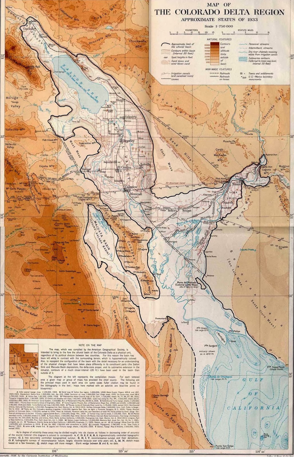
Over the centuries, the Colorado River would refill the dry basin, transforming it into a great fresh-water lake, known as Lake Cahuilla (KA-wee-ah). The river, running over the raised delta plain which sloped both ways, could easily be diverted to either side. Artesian borings at Holtville in 1913 showed sedimentary deposits in that part of the Imperial Valley are more than 1,000 feet in depth. No one knows for sure, but in all probability the Colorado alternately flowed into the Salton Sink every four or five hundred years, swinging back and forth across its delta plain. For three centuries or more, from 1540 to 1902, the Salton Sink was a hot, and arid desert.

People didn't really become interested in the Salton Sink until the late 1800's. Native Americans had harvested salt on the flats of the Salton Sink since early times. George Durbrow, a San Francisco businessman, begun work on the salt beds in 1884 and founded the New Liverpool Salt Company. The vast salt deposits, comprising over 1,000 acres of unusually pure rock salt, were considered one of the largest in the country. During the company's active years, Cahuilla Indians provided the labor force.

When the full flow of the Colorado River moved north through Imperial Valley and into the Salton Sink in 1905, it soon covered the plant. By 1907 nothing remained above the surface of the newly formed Salton Sea.
The old salt works inundated by rising waters in 1906.

The cause of the flooding was due to silt from the Colorado River clogging the canal that supplied water to the Imperial Valley in 1904. A new cut was made to reconnect the river to the canal four miles south of the international border. However, the winter of 1905 brought with it unprecedented flooding of the Colorado River. Eventually the water overflowed the canals and the full might of the river flowed into the Salton Sink. For the next two years a desperate battle was waged between man and nature, with man struggling to return the river to its original course. The result was a great inland lake 230 feet below sea level, spanning 35 miles long and 15 miles wide. The Southern Pacific Railroad was forced to reroute 40 miles of track to higher ground.

The flooded Southern Pacific Railroad line.

The original course of the Colorado River into the Gulf of California laid dry as its waters now filled the Salton Sink.

The New River cutting its channel near Calexico in 1906. Earlier, this wasn't more than a small dry desert wash.

In modern times, the New River has been considered one of the most polluted in the world, with raw sewage and industrial waste from Mexico flowing towards the Salton Sea. However it looks like steps have been taken to clean it up. Here's some info from Wikipedia on it:
"According to the Imperial Irrigation District, although water pollution is a severe problem at the border, by the time the river enters the Salton Sea, the issue is "not significant"; water quality improves as the water makes its way north due to the addition of agricultural drain water and through natural cleansing occurring in the intervening 60 miles. Agricultural pesticides have never been detected in the Salton Sea at levels high enough to cause a public health concern."
The combined efforts of the Southern Pacific Railroad and the U.S. Government finally put an end to the flooding on January 27th, 1907. Rock trains came from as far away as 480 miles to dump 2,057 carloads of rock, 221 carloads of gravel, and 203 carloads of clay in just 15 days from two trestles built across the river break. The Colorado River was returned to its former course, but it left in its wake today's Salton Sea.
Check out this article from the San Diego Historical Society on the effects of the flooding of Imperial Valley: When The Imperial Valley Fought For Its Life
From the 1920's to the 1960's the Salton Sea became a popular resort-type area. Swimming, boating, and fishing attracted crowds from all over Southern California. The State Department of Fish and Game began to introduce a variety of sport fish as early as 1929 but it wasn't until 1950 that a major effort to establish a sport fishery began. By the end of 1951, 34,000 fish of 35 different saltwater species had been trucked from the Gulf of California into the Salton Sea. Gulf croaker, sargo, corvina, and tilapia became the primary species perused by anglers. Although a few other species may still survive somewhere in the sea, due to its high salt content, tilapia are pretty much the only fish anglers are able to catch today.
Speed boat racing became a popular attraction on the Salton Sea.


All too soon, however, paradise would be lost. The increasing saltiness of the water, coupled with alge booms, which depleted the amount of dissolved oxygen in the sea caused large numbers of fish to die and the water to became less inviting. Unfortunately, newspaper pictures of beaches lined with dead fish gave the impression that this was an everyday occurrence. This, in addition to a couple of hurricanes in the 1970′s, caused the communities surrounding the sea to deteriorate.
Its easy to see why some call this "Poor Man's Baja." It was time to show my family around the place.

Friday after work we headed out and made our way to the Mecca Beach Campground.

A shot of our camp on Saturday morning. Since we didn't plan on any off-highway driving, we took our newly acquired 2011 Chevrolet Tahoe instead of the Jeep Wrangler. With the three of us and all our gear, there was room to spare inside and it drove like a dream.

Time for an early walk on the beach.

Day use area of the campground.

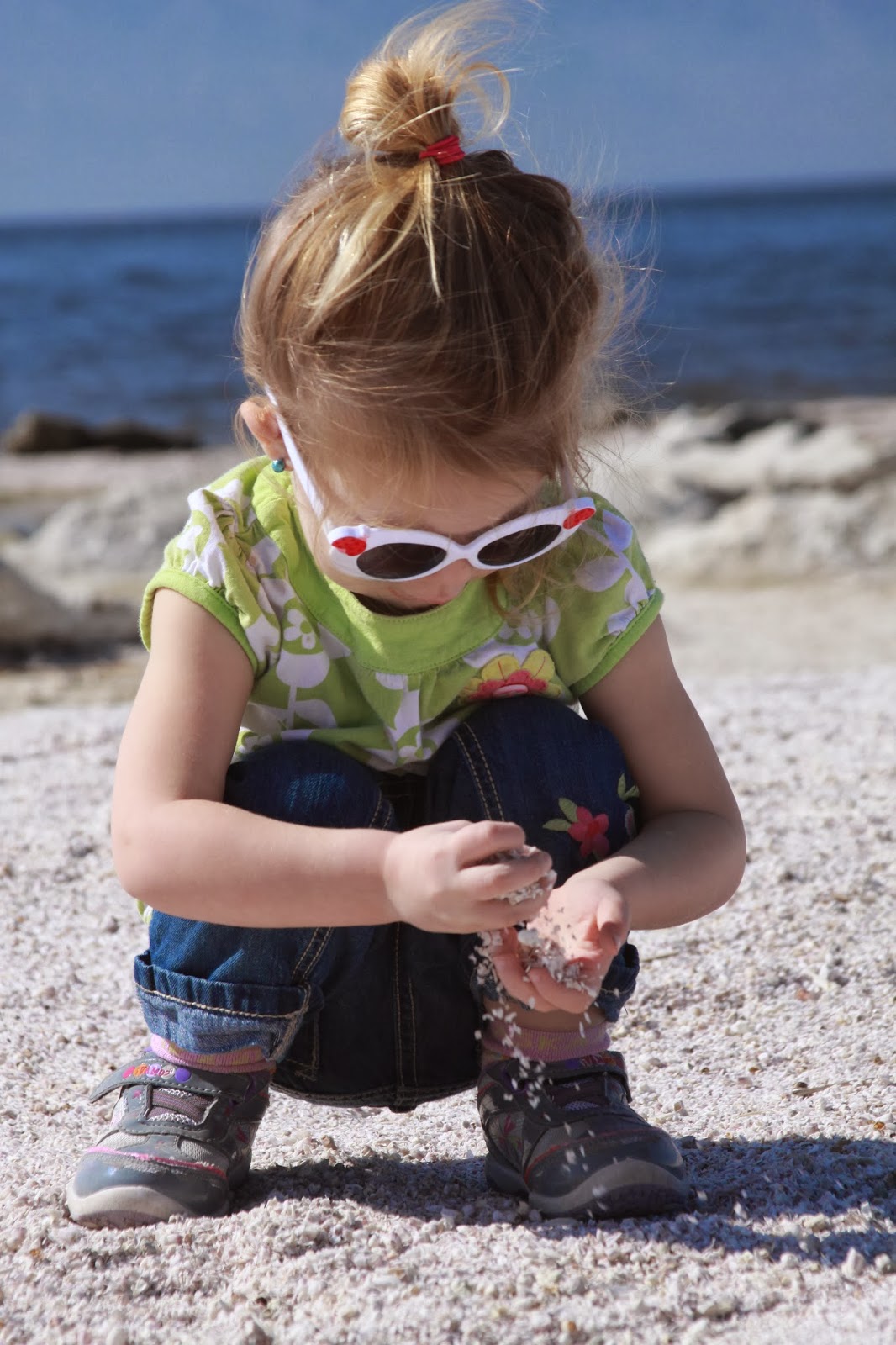
At many locations the beach is actually made up of barnacles and the pulverized remains of fish bones. The water is also saltier than the Pacific Ocean.

Checking out some of our neighbors. My mother has always liked these VW camper vans. She's had a few of the regular ones herself over the years.

We would see this nice Sportsmobile a few times while out exploring other areas.

The State Park rangers came by and issued a citation to the guy parked right behind us for skipping out on the camp fees. They also kicked him out for harassing a few of our fellow campers. Go figure, only in a developed campground...

We always enjoy our morning coffee, especially with great views like this!

Audrey having fun around camp with her bubble blower.

After breakfast, we would head North along Highway 111 for our first stop of the day, the North Shore Beach & Yatch Club which use to be a museum. Unfortunately, it was now closed on the weekends.

The North Shore Beach and Yacht Club was built in 1960. During the early 1980s, flooding from excessive agricultural wastewater discharges from Imperial Valley farms in conjunction with higher-than-normal seasonal storm runoff began to inundate the marina and surrounding property. One such flood in 1981 destroyed the marina’s jetty making it impossible to dock boats. Eventually the facility was closed by 1984 .

Restoration of the yacht club building was completed in 2010 and reopened as a community center and museum for the Salton Sea. The museum’s tenure at this prime location was short-lived however; Riverside County officials decided not to renew the operational arrangement with the museum staff and it was moved to a new location in Mecca, which has since closed. The museum staff is currently looking for another location. Click here for more info: http://saltonseamuseum.org/

Autumn, showing off her baby-bump.

Hey, I can get in on this too!

Our next stop further North was the Salton Sea Visitor Center, where we would also meet up with our friends Mitch and Apryl, who were joining us for the day.

Along with a seven minute video on the history of the Salton Sea, the visitor center displayed various fossils, animal skeletons, and taxidermied creatures. There were also books, clothes, and other merchandise available for purchase.


"The Cahuilla (KA-wee-ah) People had hunted, fished, and farmed in this area for many, many generations and still live around the Salton Sea. Rock art created by the ancestors of today's Cahuilla People gives us a glimpse into the past. Some of the symbols left behind may convey messages telling of clan boundaries, trail markings, or good hunting areas. Other designs might have been created during sacred rituals and may describe spiritual journeys. Archaeological sites are found throughout this area. Please help us protect the remnants of California's rich cultural heritage."

Besides the visitor center, there was a general store where you could rent kayaks, buy food, bait and other supplies.


Autumn wasn't too fond of the idea of getting our own bug case to display on the wall.

Golden Eagle.


Nearing the shore here you came across these stagnant, smelly pools cut off from the main lake.


Audrey wasn't too sure what to think of the "sand" here.

After playing around a wooden bench, I had to pull a few splinters out of her little hand.


After checking things out here, we made our way South to the small community of Bombay Beach. At the far west side of town along the shore you can still see the devastating effects of tropical storms Kathleen and Doreen from 1976 and '77.

I can see why this area is often described as post-apocalyptic. The ruins here are also a popular destination for photographers.

Bombay Beach ruins. A dike was built after two hurricanes in the mid-70's had raised the level of the Salton Sea and wiped out a large portion of Bombay Beach. This appears to be part of the area that was wiped out.


My baby girl playing along this desolate shore.

(Photo by Apryl.)
Another shot from Apryl.

Remains of a municipal pier that was underwater for an extended time.

Equipment from the Universal Crane Company of Lorain, Ohio continues to decay on the Bombay Beach shore of the Salton Sea.

Looks like it needs a little oil...


Mitch and Apryl stroll past a dead seagull on Bombay Beach.

It didn't seem like there was too much going on around here. At least they have their own fire station.

I've heard that the bar here at Ski Inn is a rather unique, off beat place. People tape dollar bills with messages written on them to the ceiling. I'll have to make it a point to have cold beer here next time.

Soon we were on the road again heading South towards our next points of interest, Salvation Mountain and Slab City on the outskirts of Niland.


All this is from the work of one man: Leonard Knight. Unfortunately, the day after getting home from our trip here, we had learned that Leonard had passed away at the Eldorado Care Center in El Cajon, where he had lived for more than two years after failing health forced him to reluctantly leave his mountain. He was 82.

He spent three decades and used about 500,000 gallons of paint creating a tall mound of adobe east of the Salton Sea with pastoral scenes and biblical quotes imparting the message that 'God is Love.'

An interesting fact is that Knight played himself in the 2007 movie "Into the Wild," directed by Sean Penn, with a scene set at Salvation Mountain. The movie brought even more visitors to the mountain.

Taking Audrey to the top, along the 'yellow brick road.'

Official Salvation Mountain site: http://www.salvationmountain.us/
Slab City is an informal, off-the-grid community in the California desert.

From Wikipedia: "Slab City or The Slabs is a snowbird campsite in the Colorado Desert in southeastern California, used by recreational vehicle owners and squatters from across North America. It takes its name from the concrete slabs that remain from the abandoned World War II Marine barracks of Camp Dunlap. The site is both decommissioned and uncontrolled, and there is no charge for parking. The camp has no electricity, no running water, no sewers nor toilets, and no trash pickup service. Many campers use generators or solar panels to generate electricity."
Here is the site dedicated to the preservation and clean up of Slab City: http://www.slabcity.org/
The community bulletin board.

The Shoe Tree.

The bedazzled truck across the way.

Looks like the locals hang out at the The Range.

From what I could tell, its an open-air nightclub complete with stage, lights, amplifiers, speakers and tattered couches and old chairs for seating.

I wonder what the story behind this burnt out camper is?

For lunch, we stopped at the Coachella Canal, a 122-mile aqueduct that conveys Colorado River water for irrigation from the All-American Canal to the Coachella Valley in Riverside County, California. I was sad to see it fenced off, since its a great place to fish.

"East Jesus is an experimental, habitable, extensible artwork in progress since 2006 begun by the late Charles Stephen Russell in Slab City, California. The inhabitants of East Jesus and offsite members provide a refuge for artists, musicians, survivalists, writers, scientists, and laymen. They are dedicated to providing a working model of an improbable improvised community. Completely self-contained and run entirely on solar power, East Jesus attempts to use and recycle every bit of consumable trash. They are unique in the Slabs in that they have Human Manure composting to reduce and improve the impact on the local desert environment."


And they say there's nothing good on television anymore.


As the afternoon rolled along, we parted ways with Mitch and Apryl so we could make it back to camp before nightfall and get dinner started.

In no time at all we had the campfire going and dinner cooking.

Dinner consisted of grilled steak and campfire cooked potato and yellow squash melody wrapped in tinfoil.

We also got a surprise visit from my wife's parents and sister. They just stayed for the evening to enjoy some roasted marshmallows.

The next morning we packed up and headed out to a few more spots.


is one of the few standing historic structures in what was historically the town center of Niland. I think it would be neat to see it restored someday.

Another possible fishing spot?

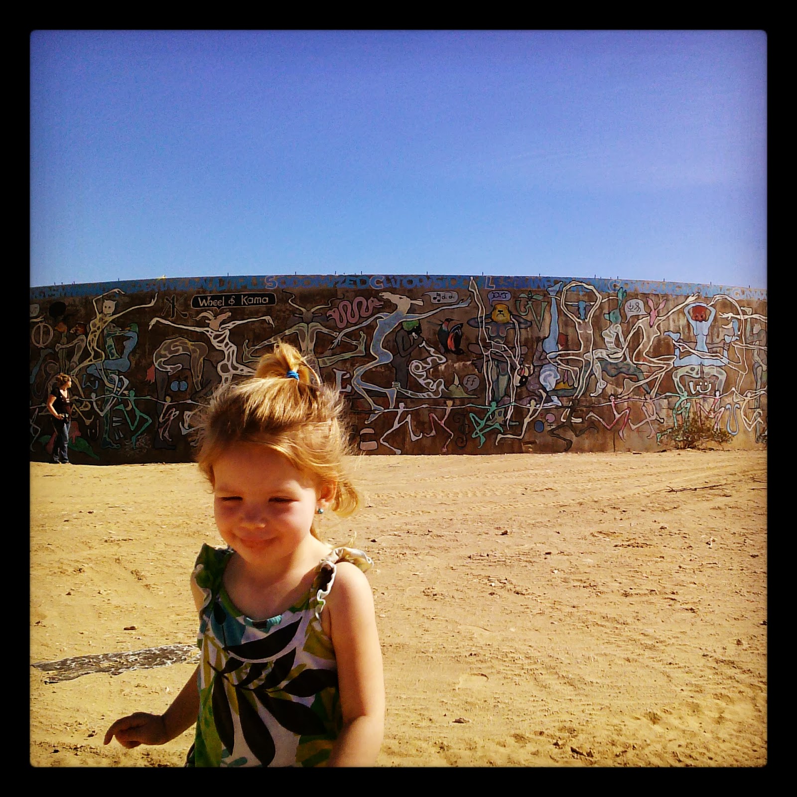
On our way to the Slab City Water Towers, which are now folk art murals. "The Wheel of Kama" and the "Wheel of War" are not associated with Salvation Mountain, but are a worth checking out if you're in the area.

Dragon on the "Wheel of War"- made from shotgun shells, many of which are now missing.

She wanted a photo next to the, uh... animals.

These concrete structures are located a bit West of the water towers, just below the ridge that marked the ancient shoreline of Lake Cahuilla.

Another shot of the old shoreline. Lake Cahuilla was possibly one of the largest lakes of the past. It was a huge freshwater body covering over 2,000 square miles to a depth of more than 300 feet. The lake was almost 100 miles long by 35 miles across at its widest point, six times the size of the present Salton Sea.

Waking along the old shoreline reveals beach rock, smoothed by wave action. One of these day I'll have to devote an entire trip to exploring the remnants of this ancient lake.

Arial view of Niland, Salvation Mountain, and Slab City where you can see the high water mark of ancient Lake Cahuilla. The shoreline is still visible at the base of the surrounding mountains. It averages about 40 feet above sea level, but varies from 25 to 50 feet elevation. The variability of elevation is thought to be due to subsidence of the basin floor.


The next stop on our list was a 32,700-acre wildlife refuge created in 1930 by Congress to ensure protection of the habitat for the 426 avian species that live or seasonally migrate there. Known today as the Sonny Bono Salton Sea National Wildlife Refuge, it is located on the Pacific Flyway, an important migration route for birds. The refuge habitats and the Salton Sea are vital to these migrating birds as a resting place and wintering area.

Additionally the refuge manages an intensive farming program to provide forage for as many as 30,000 wintering geese and other migratory birds and wildlife in winter months. Winter brings big numbers of geese, cranes, swans, ducks and other shore birds that spend the season here.

Along with a museum-like visitor center, there was a large wooden viewing platform.


Desert pupfish pond.

In one of the palm trees a barn owl was sleeping, waiting for the night shift.

While the girls had lunch, I walked the two mile round trip to Rock Hill. The views from the top were fantastic.


More info and directions to the refuge: Sonny Bono National Wildlife Refuge
We made a quick stop at the "Three Sisters" which is another spot popular with photographers.


On our way to check out the campground at Red Hill Marina. The access road is a causeway that used to have water on both sides.

This area was kind of a disappointment. There was no one at the ranger station and the whole place looked rather run down, with old campers that seemed to have been sitting there forever with sketchy-lookin' people still living there. I was hoping this might have been another possible place to camp but after seeing it in person... uh, no.

The day use area looked okay, but I'm sure it'd be better if the shoreline was closer.


Dry boat ramp at Red Hill Marina on the Salton Sea.

This shows just how far the water has receded from the access channel for the boat ramp at Red Hill Marina. I'd bet that the degraded state of this campground is due to the lower water level.

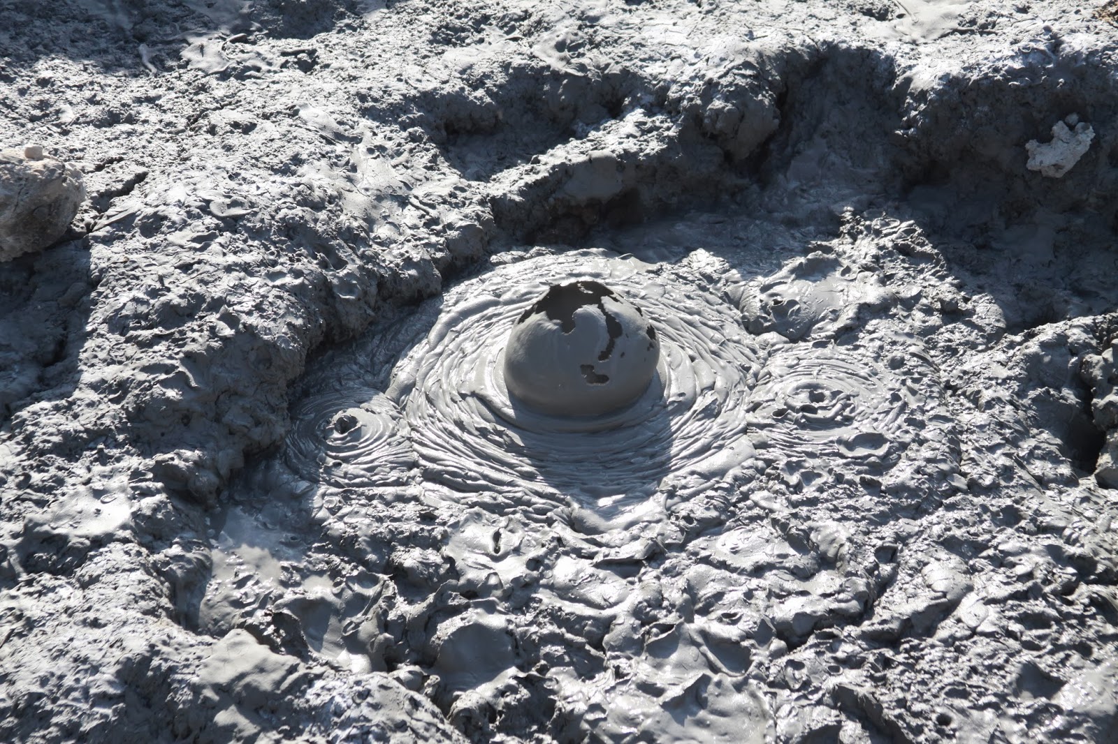
A few minutes away was another sight along the Salton Sea that I've wanted to see. The geothermal mud volcanoes can be hard to find but are well worth the effort. Off a dirt road on the muddy flats near the eastern shore of the Salton Sea, carbon dioxide slowly bubbles up to the earth's surface.

This set of mud pots is officially called "The Davis-Schrimpf Seep Field". They come in all different sizes and make plenty of noise- popping, fizzing, rumbling, whizzing and boiling.

This makes for an interesting little adventure. If you come here don't make this something they have to 'protect' because people abuse it. With a little respect, future generations can enjoy this treasure as much as I did.

This last stop marked the end of our exploration of the Salton Sea and nearby areas. You can bet that one day, I'll be posting up another Salton Sea adventure here. There are some places I'd like to revisit along with other aspects of this area that I still need to explore. The tires of our now dusty Tahoe soon found pavement again as we made our way South on Highway 111 to Interstate 8, all the way back to San Diego. Whether staying at a developed campground or getting away from civilization via some remote back country trail, its these kind of trips that feed my adventurous spirit. And of course, its all the better having my loved ones along to share it with.

Other great sites and blog post on the Salton Sea and surrounding areas:
The Last Adventurer - Salvation Mountain
The Last Adventurer - Wheel of Kama and the Wheel of War
The Adventure Duo - Tour de Salt
The Salton Sea Speaks