Saturday, December 31, 2016

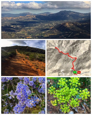
Hike #39 Long Valley Peak

52 Hike Challenge 2016 Adventure Series


5 miles | +1600'


Scenes from hiking Long Valley Peak. There isn't much info on this peak but it's easily seen from Interstate 8 near Pine Valley. It appeared to be a massive mountain capped with granite and surrounded by brush. There are several routes which lead to the summit of this seemingly seldom visited peak.

Hike #38 Blue Angels Peak

52 Hike Challenge 2016 Adventure Series

6.75 miles | +1300'


Blue Angels Peak is the highest point in Imperial County. It's located in the very southwest corner of the county, less than 300 yards north of the United States-Mexico border. The peak also lies just west and adjacent to the Jacumba Wilderness Area, so designated as part of the California Desert Protection Act of 1994. A broad range, the Jacumbas are really a series of almost parallel ridges separating valleys, with each ridge successively lower than the next, forming a great staircase descending eastward into the Colorado Desert. South of the border these same mountains stretch about 100 miles into Mexico, where they are known as the Sierra Juarez.

The terrain is rocky, dry, and desolate, a classic southern California desert landscape, with outstanding views in all directions.

Blue Angels Peak might be climbed more often by illegal immigrants using it as a lookout point to avoid the US Border Patrol, than by citizens of the United States. It's original name was Smuggler's Peak (which is inscribed on one of the three USG markers found near the summit), testifying to this.

International Boundary Marker 231, a ten-foot steel obelisk, is located just south and a little west of the peak. These markers are numbered consecutively along the border from #1 at the Gulf of Mexico shoreline east of Brownsville-Matamoros to #258 at the Pacific Ocean.


The peak was named in honor of the Navy Flight Demonstration Squadron, the Blue Angels, which is based at a nearby naval air facility in El Centro.

Hike #37 Crest Canyon & Torrey Pines State Reserve Extension

52 Hike Challenge 2016 Adventure Series


7.25 miles | +750'


Crest Canyon Open Space Park Preserve is a wonderland of steep, orange sandstone cliffs and slopes dense with fragrant coastal sage scrub and southern maritime chaparral.

Lying between Del Mar and Del Mar Hills, Crest Canyon is carpeted with California buckwheat, bush sunflower, lemonadeberry, prickly-pear cactus, the bayonet-like yucca, and toyon, also known as California holly, the tree for which Hollywood was named.

The plant community includes two endangered species. The magnificent Torrey pine grows only on our North Coast and on Santa Rosa Island off Ventura. The tiny, delicate succulent, Dudleya brevifolia, produces star-like, cream-colored blossoms with bright yellow-green centers touched with red, like flecks of blood.

At orange dawn and dusk, the canyon is alive with birds and rabbits. The canyon provides a home for the threatened California gnatcatcher and for the California quail and the California towhee. The canyon is a stopover on the Pacific Flyway for migrating birds from faraway places.

Crest Canyon originally was included in the plan for Torrey Pines State Reserve but was omitted because of concerns about cost. The canyon was badly eroded by increased runoff from the development of the Del Mar Hills neighborhood in the late 1960s. Crest Canyon was saved from development in the 1970s by local activists who persuaded Del Mar and San Diego to buy and restore the land for public use.

Most San Diego residents can probably tell you where to find the rare Torrey Pine, whether or not they realize the tree’s uniqueness. That’s because the well-known Torrey Pines State Natural Reserve between La Jolla and Del Mar offers beautiful ocean vistas, secluded hiking, and, of course, plenty of opportunities to see Torrey pine trees in their natural habitat. Slightly less famous, but equally worthwhile, is the Torrey Pines State Reserve Extension, located just across Los Peñasquitos Lagoon from the main reserve. These less-traveled extension trails offer spectacular pine specimens as well as a rich collection of other coastal sage scrub and chaparral plant life.

While a stroll through either the main reserve or the extension may convince you that the magnificent Torrey pine is relatively abundant, it grows nowhere else in the world except a thin strip of coastline south of Del Mar and a tiny fragment on Santa Rosa Island of the Channel Islands. With only a few thousand individuals in the wild, the Torrey pine is considered rare, threatened, and endangered by the California Native Plant Society. It is a perfect example of why San Diego is globally known as a “biodiversity hotspot,” a region with very high numbers of plant and animal species, particularly endemics, or species that occur nowhere else.


The dry, sandy soils favored by the Torrey pine are also preferred by a variety of other San Diego natives. This coastal sage scrub habitat is rich with wildflowers, various shrubs, and, as the name suggests, sage. Both white and black sage can be found here, as well as the unrelated (except in smell) California or coastal sagebrush. California poppy and sunflower bloom here in late winter/early spring, with many additional wildflowers blooming in the spring months.

Hike #36 Jacumba Peak

52 Hike Challenge 2016 Adventure Series


5.5 miles | +800'


Jacumba Peak sits at an elevation of 3363' just north of Jacumba Hot Springs. Based on peakery data, it ranks as the 3655th highest mountain in California. The U.S. Border Patrol have used the summit as a lookout point.

Jacumba Hot Springs is a small town in southeastern San Diego County. The town’s name was recently changed to attract visitors to the Jacumba Hot Springs Spa. Previously, is was just Jacumba. This town is chiefly notable for its hot springs and spa, and a large nudist resort. A massacre that occurred in 1880 has been largely forgotten. The town has a population of about 550. It is located 70 miles east of San Diego on Old Highway 80 about 5 miles west of the Imperial County line and ¼ mile from the US/Mexican border. Jacumba lies at 2800′ in a large valley, most of which is in Mexico. A stout metal fence runs along the border just south of town.

For years I've enjoyed off roading and quail hunting in the surrounds hills of this area. The valley just below the peak was previously accessible to the public, but in recent years the landowner has kept the gate locked. This makes for a somewhat awkward, but more enjoyable cross country approach to the peak.

Hike #35 Kwaay Paay Peak

52 Hike Challenge 2016 Adventure Series


2.5 miles | +900'


The shortest and steepest hike within Mission Trails Regional Park. Flanked by steep walls on all sides but one, this summit stands quite aloof from all else around it. The peak offers a unique vantage for tracing the lower San Diego River's course and seeing how its flow carved the granite walls of Mission Gorge.

Hike #34 McGinty Mountain

52 Hike Challenge 2016 Adventure Series


5.5 miles | +1200'


McGinty Mountain is considerably less popular than some of the county’s more well-known peaks, like Cowles Mountain, Iron Mountain, and Mount Woodson. This can only be due to its comparatively remote location, because it is a beautiful and challenging hike with some amazing views.

The trail and surrounding area are managed by the US Fish and Wildlife Service, and is part of the San Diego National Wildlife Refuge. McGinty is home to several rare species of plants such as Deheasa beargrass and San Diego thornmint that grow in the area’s unique gabbro soil. There are also old mines scattered about the area.

Hike #33 Los Peñasquitos Lagoon

52 Hike Challenge 2016 Adventure Series


3.75 miles | +160’


Los Peñasquitos Lagoon, one of San Diego County’s largest coastal wetlands, spreads far and wide in Sorrento Valley, between La Jolla and Torrey Pines. Nearly all of this marshy area belongs to Torrey Pines State Reserve. The marsh trail skirts the southern edge of the wetlands for 1.5 to 2 miles, depending on how muddy you're willing to get.

Los Peñasquitos Lagoon is one of the known breeding grounds in California of mosquitoes infected with the West Nile virus.

Deer are found in the marsh area, and often carry ticks that are left behind on vegetation that can brush against hikers, whereupon the ticks are often inadvertently transferred to hikers. A warning sign along the Marsh Trail reminds hikers that rattlesnakes are also found in the marsh area.

Although mountain lions (Felis concolor) are now rare in the Torrey Pines and Los Peñasquitos Lagoon area, likely as a result of habitat fragmentation, mountain lion tracks and scat were reported between Interstate 5's bridge and Los Peñasquitos Lagoon in 2000 by the Conservation Biology Institute in Encinitas.