Wednesday, February 22, 2017

Hike #2 Carrizo Mountain

12.5 miles | +2100'


I've taken my Jeep up Carrizo Mountain for years but this was my first time hiking to the actual summit. It was interesting to read entries in the summit register dating back to 1979.


The United States Congress designated the Coyote Mountains Wilderness in 1994 with a total of 18,631 acres. All of this wilderness is located in California and is managed by the Bureau of Land Management. The fishhook-shaped Coyote Mountains cover about 40 percent of this austere Wilderness, a desert land of low ridges and washes capped by the forbidding Carrizo Badlands to the north. Carrizo Mountain and the striking Painted Gorge lie in a non-Wilderness corridor that punches in from the eastern boundary.


The highest point of the Coyote Mountains is Carrizo Mountain, at an elevation of 2,408 feet. An old mining road winds through Painted Gorge and up the hills to a turn-around a few hundred feet below the summit. A use-trail and some cross-country makes for an easy hike to the top. The mountains sit within the Yuha Desert Recreation Area, which features tracks for off-road vehicles. The badlands below the range extend many miles north and east, and are popular with the off-road crowd. A few venture into Painted Gorge and to the turn-around up high, but the road up high is narrow, steep and rocky with some very exposed sections demanding an experienced off-road driver.


This road serves as the natural route to the top. In Fall and Winter, this is an enjoyable hike, and especially when the gate is closed (Jan 1 to June 30), you will probably have the mountains to yourself. It's very remote, stark desert, and very peaceful. The mountains feature no significant brush other than ocotillo, barrel cactus, creosote and shrubs. Wildlife includes the Peninsular Bighorn Sheep, and as usual, snakes when warm. Summer is very hot: things heat up as early as March and stay warm even into October.


The entire area falls within the Yuha Desert Recreation Area, and Anza-Borrego Desert State Park lies immediately to the north. You'll find unusual sandstone formations that are estimated to be six million years old, adding a touch of scenic character to the area. On the mountain ridges, you may be privileged to see a barefoot gecko or bighorn sheep.

Hike #1 Agua Caliente Creek via PCT

10 miles | +1000'


First hike of 2017! Agua Caliente Creek via Pacific Crest Trail. I hiked this back in September of 2015 and it was bone dry. So I've been waiting for some rainfall to bring the creek bed back to life and it did not disappoint. The sound of water flowing, gurgling, and splashing down the canyon was delightful! Trails through the trees puts me at ease.


"Some of the loftiest- and least visited mountain country in San Diego County surrounds the resort community of Warner Springs. Before the 1970's the canyon of Agua Caliente Creek above Warner Springs seldom saw the intrusion of humans. After the Pacific Crest Trail was routed through, however, it became recognized as a pleasant camping spot for backpackers heading north toward Canada or south toward Mexico. This is one of only four places in San Diego County where the PCT dips to cross a fairly dependable stream, and the only place in the county where the trail closely follows running water for a fair distance."- Jerry Schad


So towards the end of my hike I began to feel something irritating the skin on my neck. I felt it and didn't recall having a mole there. A photo from my phone confirmed my fears... A tick in my neck! A western black-legged tick, to be exact. I didn't want to mess with it until I could see what I was doing with a mirror and I was still two miles away from the trailhead. Fortunately, I came across another hiker who agreed to help me out. So out came the tweezers from the first aid kit and soon I was free of the little blood sucker.


Here in Southern California, tick season runs typically from November through May, when cooler, wetter weather makes the pests more active and more likely to crawl on humans or pets in order to bite and feed on blood. The National Centers for Disease Control and Prevention (CDC) recommend removing ticks by grabbing them with tweezers as close to the insect’s head as possible and pulling out steadily and firmly.


Scouting out campgrounds after my hike. Indian Flats Campground is a small 17-site campground in the Cleveland National Forest near Warner Springs. The campground lies within a sunny live oak woodland at 3,600 feet, located below Hot Springs Mountain, the 6,533-foot high point of San Diego County. Granite outcroppings around the campground offer picturesque sunset perches or fun places to climb around during the day. There is a short trail from the campground to the East Fork of the San Luis Rey River, where you will find shallow pools to explore at the end of the winter wet season.

Friday, February 17, 2017

Exploring San Diego County, SoCal, & Beyond

THE 52 HIKE CHALLENGE IS A GLOBAL MOVEMENT INSPIRING YOU TO TAKE A PERSONAL JOURNEY TO DISCOVER THE PHYSICAL, MENTAL, AND SPIRITUAL BENEFITS GAINED THROUGH HIKING ONCE A WEEK FOR AN ENTIRE YEAR. THOUSANDS OF PEOPLE ALL AROUND THE WORLD ARE TAKING THE CHALLENGE TO HELP CHANGE THEIR LIVES IN A POSITIVE WAY, ONE STEP AT A TIME.


2017 Explorer Series

Are you ready to take on a life changing journey?  Are you ready to do whatever it takes to complete the challenge, including meeting new adventure partners and exploring places you have never been before?  If so, we welcome you to the challenge!

THE EXPLORER SERIES IS YOUR CHANCE TO EXPLORE 52 NEW TRAILS!

For 2017 we decided that it would be a true challenge for some people to explore a new trail every week. Several challengers have already done so, and have inspired us to get you to explore some new places you may not even know about. *You can do various trails in one park and make the hike different each time as well.

So what are you waiting for? Get out and explore!

Wednesday, January 25, 2017

My Top Twelve 2016 Hikes

Here are my top twelve hikes for 2016, in no particular order. This is always such a difficult list to make, since I enjoy each and every one of my outdoor adventures. Even if it's a trail I've already hiked before, I still take away something new from it... a new sight, experience, or feeling.

It might be an enhanced connection to the natural world, learning something new about myself or working out whatever issues I have in my own head during a solo hike, the look of wonder and joy on the faces of my children as they explore, and of course the comradery of an adventurous group; who might just find themselves in an unexpected situation while taking an alternate route. Keep calm and hike on!

Villager Peak
Coyote Canyon
El Cajon Mountain
Peak 6582
San Jacinto Peak
Devils Canyon/Meyer Creek
Cuyamaca Peak
Fred Canyon to Burnt Ranchita via PCT
Sunset Cliffs Natural Park
Blue Angels Peak
Tahquitz Peak
Goat Canyon Trestle


52 Hike Challenge 2016 Recap

All of my hikes in 2016. A total of 418.5 miles and 72,520 feet of elevation gain. Looking forward to what 2017 brings!


Saturday, December 31, 2016

Hike #67 Horsethief Canyon

52 Hike Challenge Adventure Series

3.5 miles | +500'


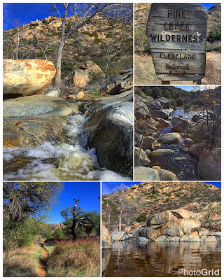
"The Cleveland National Forest's Pine Creek Wilderness, created in 1984, encompasses more than 13,000 acres of chaparral covered slopes and riparian woodland south and west of the Laguna Mountains. A 15 mile stretch of Pine Valley Creek meanders through the heart of the wilderness, flanked by sloping walls up to 1000 feet high. Motorists eastbound on Interstate 8 can catch a glimpse of this impressive gorge when crossing the Pine Valley Bridge, the highest bridge in the Interstate Highway System." -Jerry Schad

Hike #66 Cuyamaca Peak

52 Hike Challenge Adventure Series

6 miles | +1700'


Barely an hour's drive east of central San Diego lies San Diego County's largest and most varied mountain recreation area: the Cuyamaca Mountains. The elevation here ranges from about 3500 feet at the rural community of Descanso at the south end of the range, to a maximum of 6512 feet at Cuyamaca Peak, the second highest summit within San Diego County. 

On a few days each year, when snow accumulates, it is possible to reach the summit of Cuyamaca Peak on cross-country skis. The steepest, uppermost parts of the trail, however, make for a slippery and possibly dangerous decent.

This was my first real snow hike. I had to break through a foot of snow to reach the peak. The whole hike took an additional two hours to complete and I was exhausted after postholing through it all.